Key points:
- Farm land across northern Victoria is submerged by floodwater
- Dairy farms have been left without electricity and crops are submerged
- More than 50mm of rain is forecast for some parts of the state later this week
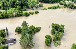
There was optimism floodwater around Shepparton had peaked at a lower level than expected, however a forecast predicting more rain later in the week has farmers concerned.
The Loddon River is expected to peak on Tuesday night into Wednesday and may reach levels similar to the January 2011 floods.
That prediction would mean the town was isolated for up to two weeks.
It would also mean Dale Trevorrow, who lives in Kerang, was isolated from his farm for an extended period.
Mr Trevorrow is a grain grower and livestock producer with a property on the Loddon River flood plain.

He has been busy making preparations for the peak of the water, including moving livestock to higher ground.
“We’ve got a lunette at the back of Murphy’s Lake which was the only bit of ground out of water in 2011. Sixty-five acres out of 3,500 was under water,” he said.
“We’ve moved our stock adjacent to that paddock and two neighbours have put sheep and cattle on that hill.
“We had a neighbour in 2011 who was able to drag a hay trailer around and fed out stock on the hill for us that year.
“The neighbour’s son now owns that property and he’s going to feed stock for us if we can’t get out.”

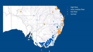
Towns across northern and eastern Victoria are feeling the brunt of the flood crisis.(ABC Graphics)
Electricity cut
Major flooding has already hit the Goulburn River near Shepparton.
Rick Cross brought in a generator to run his dairy at Toolamba, between Murchison and Mooroopna, and milk his cows over the weekend .
“We’re completely surrounded by water but we’ve been able to keep the cows off the irrigated country because they’d just completely destroy that,” Mr Cross said.
“We’ve been wet for three months and this has just made it even worse.
“We’re probably one of the lucky ones, we’ve got a very undulating farm and we have [120 hectares] of dry country.”

Mr Cross said he was nervously watching the rain forecast for later this week.
“We’re going to go through it all again and it’s going to be tough. I hope the Bureau gets it wrong, but they were pretty right with the last one,” he said.
‘Severe’ flooding at Charlton
The Avoca River at Charlton peaked at 7.87 metres – above the major flood level of 7.5 metres — in the early hours of Monday morning.
Stuart Giles, who farms just downstream of Charlton, said he had a “pretty severe flood” across 400 hectares of his flood plain country.
He said the water was moving slowly.
“It seems to be sitting there. Normally a flood comes up and drains away, but this seems to be hanging around for a while, so it could do a bit of damage,” he said.
“The crops are extremely heavy and dense and that does slow the water down, but also we’ve had heavy rains all up the catchment.
“We’ve got local water for a start that got the river up, then we got the rain from all the way to Avoca, so it’s just been a continuous flood that’s lasted quite a while.”
Where to find emergency assistance and information
- For emergency assistance, contact the SES on 132 500
- If your life is at risk, call triple-O (000) immediately
- You can find the latest Victorian evacuation orders here
- For the latest weather updates visit the Bureau of Meteorology.


