Here’s how El Niño could impact Midwest weather this fall and winter.
What will fall weather for harvest and the ensuing winter be like in the Midwest? You would likely pay a considerable sum if you could get an answer with a guarantee.
There are no guarantees when it comes to weather forecasts, says Eric Snodgrass, a longtime agricultural climatologist with Nutrien. That was crystal clear earlier this year when weather forecasters looking at preseason weather indicators failed to see drought coming in late May and June across the Midwest.
“Weather forecasting is improving all the time, and accuracy has increased, but long-range forecasting is still speculative,” Snodgrass says. “Beyond 10 to 15 days, if someone tells you they can forecast exactly what it will be like on a certain day, you should be skeptical. We are getting better at predicting trends, but not exact conditions.”
El Niño returns
“The thing we know for sure is that after three straight La Niñas, El Niño is now underway, and can influence global weather patterns — especially in the Midwest,” Snodgrass says.
El Niño refers to warming sea surface temperatures along the equator in the Pacific Ocean. La Niña is the cool phase, with a neutral phase sandwiched in between. Changes in the barometric pressure lead to changes in the trade winds, which ultimately impact sea surface temperatures. This influences the Northern Hemisphere jet stream, which impacts U.S. weather systems.
What isn’t known, Snodgrass says, is how strong the El Niño will become. A strong to very strong El Niño sometimes produces different results than a mild or weak El Niño. Current indications are that it could be strong, but time will tell. Other factors in the atmosphere can also impact global weather patterns, making it impossible to predict weather trends based on the El Niño-La Niña cycle alone.
Fall and winter
Right now, fall could shape up to be different than recent falls, which featured dry stretches suitable for field work. “A late September through October transition from warmer and drier than average to wetter and cooler weather is likely,” Snodgrass says. “The result could be less-than-ideal weather conditions for fall harvest.
“One thing for certain is that we have no idea when the first killing freeze will occur. People like to talk about early frosts and freezes, but until about seven days out, the truth is, we can’t pin down an exact date or time. Frosts and freezes are extremely difficult to predict in advance.”
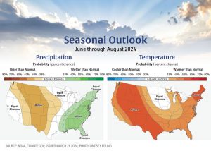
Winter could likely be different as well, although it is too early to get a firm grip on what it may look like at any one location, he says. The past three La Niña winters have been on the mild side in the Midwest, with more snow and colder temperatures tending to come in the back half of winter.
With an El Niño in play, it’s often wetter than normal and cooler than normal in the South, especially the Southeastern U.S. It tends to be warmer and drier than normal over the Midwest. How strong El Niño gets is a wild card, Snodgrass says. The crystal ball for winter is still cloudy at best.
