El Niño is over. For some regions, we hardly knew ye, while for many central and eastern areas the dry has been certainly noticeable over the past few months.
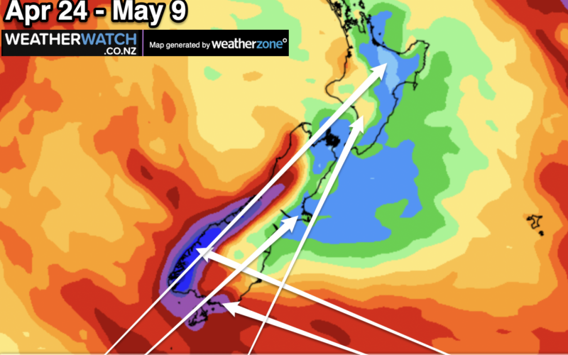
As we come into the final stretch of April and towards the middle portion of autumn, the soil moisture maps still have an El Niño hangover. Soil moisture levels are drier than usual in parts of Canterbury, Marlborough, Wairarapa. Manawatū, Horowhenua, Hawke’s Bay, Whanganui, Gisborne, Hauraki Plains/Coromandel Peninsula, and the eastern side of Northland.
This is all classic El Niño-driven dryness courtesy of more westerlies and southwesterlies, and the bulk of the rain bands have been westerly driven.
Life is returning to our weather! Marlborough, like many regions, now has a wet side and a dry side. Rain fell in recent days and again the week prior giving some locations so much rain that the soil in parts of Marlborough is now wetter than it historically would be at this time of year.
Of course, it depends on who you ask and what they do for a living if the rain has been enough, too much, or still not yet the right amount.
With New Zealand shaking the El Niño weather pattern, we transfer into an autumn pattern. It’s a bit like the difference between a sunrise and a sunset – both look the same but they are different and we just need a little more time to see that pattern leave us.
As we head more towards winter there will likely be more breaks between the highs and more chances of low pressure. As we look at the weather maps there is life all around us.
In recent days – and in days to come – we have low pressure south of NZ, east of NZ and north of NZ. But we’re still seeing high pressure zones like giant cargo ships sailing out of the Australia region to our west.
These big, slow-moving systems are still in the mix and are bringing very dry weather to places like Victoria. (Had a message on our WeatherWatchTV YouTube page just this week from someone saying they would ‘unfollow us’ if we didn’t start forecasting some rain for the wheatbelt there soon!)
So the dry weather in Victoria, and New South Wales and Tasmania is dragging over to our side of the Tasman Sea too – but we currently have better chances for rain events than our Aussie neighbours.
We’re now in a “neutral” season. Think of El Niño as first gear – it allows you to move along in a steady direction. La Niña is reverse – again, it allows your vehicle to move along in a steady direction.
Neutral is like you (or your kids) taking their first driving lesson and there’s a lot of gear grinding. As a passenger you don’t know if you’re moving forwards, backwards or stalled.
Put short, El Niño is more about westerlies and dry, but “neutral” means more weather chaos and anything can happen.
You can now read the most important #news on #eDairyNews #Whatsapp channels!!!
🇺🇸 eDairy News INGLÊS: https://whatsapp.com/channel/0029VaKsjzGDTkJyIN6hcP1K
