The weather system is making headlines again, but Phil Duncan questions whether it should be.
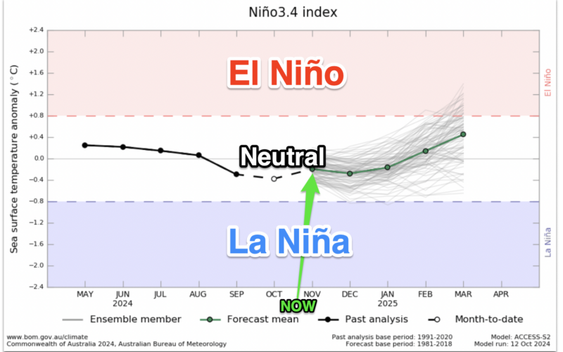
“La Niña is coming,” said the headline in a major international news outlet earlier week. But when you read the story it also said “A weak La Niña is expected”, followed by “La Niña isn’t here yet, but has a 60% chance of emerging through November” and “… it’s still unclear just how strong La Niña will get” , and also “If this year’s La Niña ends up rather weak, this outlook could shift”.
In short, this feels like one of those moments when a year of something being talked about has been more of a distraction than it has been helpful. When it comes to the actual facts, the bulk of global data and forecasters still pick November/December to be any potential “peak La Niña time”. But do you (as a government forecaster) declare it is here, when modelling suggests it won’t be here too long?
When it comes to government climate forecasters, I prefer the Bureau of Meteorology (BoM) and its “model of all models”. It shows you the average of global modelling from the most trusted nations on the planet (New Zealand isn’t on that list because NZ doesn’t provide “open weather data”, which means publicly owned data can’t be freely used and measured against other nations’ because it has been commercialised by NIWA).
This model of all models paints a clear picture of a dip towards La Niña weather conditions in November, but then racing back out of them again early in the new year. If you were to glance at that not really understanding all the fine details, what stands out quite obviously is it all ticking back upwards towards El Niño conditions (but still staying firmly in “neutral”).
As a weather forecaster this long-range stuff can be a distraction when it’s so borderline – but in saying that, it needs to be addressed like the elephant in the room. Or in this case it feels more like Moo Deng in the room (the newly famous tiny baby pygmy hippo from that zoo in Thailand).
From a weather point of view the weather maps over the coming two weeks look a lot more like La Niña to our north – low-pressure zones finally dominate in that region (including a sub-tropical storm south of Tonga on October 21).
But at the time of writing this column high pressure was the dominant factor and the Seven Day Departure From Normal Rainfall map showed the entire country leaning drier than average for this time of year. Put short: nothing in the tropics is affecting NZ in any noticeable way, yet.
I’m well aware of the irony – that I’M now the one now talking about La Niña again – but even though it’s not currently really impacting New Zealand I wanted to update you on what I’m seeing as a weather forecaster and how I view the importance of all the “La Niña news headlines” that are around.
You can now read the most important #news on #eDairyNews #Whatsapp channels!!!
🇺🇸 eDairy News INGLÊS: https://whatsapp.com/channel/0029VaKsjzGDTkJyIN6hcP1K
